


Lat Long Calc
คำอธิบายของLat Long Calc
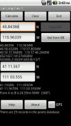
Lat Long Calc is a GPS tool that converts latitude/longitude coordinates to different formats and calculates distance and direction between two points. This is the free version. For more features look for Lat Long Calc Pro.
** If you find a bug, e-mail me and I will fix it. **
Of particular use in Search and Rescue (SAR) & GIS where conversion between different formats is needed.
Also useful in Geocaching, surveying or anything where you need to convert coordinates between formats.
Please contact me at cruthuservices@gmail.com for help before rating poorly.
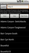
Supports DD.DDD, DD MM.MMM, DD MM SS.SSS, UTM and Maidenhead Locator. Can load points from a GPX and/or save points in local DB for later use.
Maidenhead Locator (4 or 6 digit) is useful for Ham (Amateur) Radio contacts or contesting.
Can use internal GPS to get current position which can also be saved to a local DB.
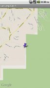
Includes mapping support. See your positions on a map. Options to use internal rendered Google Maps or external map provider such as Google Maps, or other map programs.
Long click on coordinate results to show map. Read help for more details.
Does not share any information. Internet access is for downloading your specified GPX file. GPS is only used if you select it.
Now has batter support for small screen devices.
Note: Mapping support requires Google Maps be installed.
เขตยาว Calc เป็นเครื่องมือที่มีจีพีเอสที่แปลงพิกัดละติจูด / ลองจิจูดให้เป็นรูปแบบที่แตกต่างกันและคำนวณระยะทางและทิศทางระหว่างจุดสองจุด นี้เป็นรุ่นฟรี สำหรับคุณสมบัติมากขึ้นมองหาลาดยาว Calc Pro
** หากคุณพบข้อผิดพลาด E-mail ฉันและฉันจะแก้ไขได้ **
โดยเฉพาะอย่างยิ่งในการใช้ในการค้นหาและช่วยเหลือ (SAR) และระบบสารสนเทศภูมิศาสตร์ที่แปลงระหว่างรูปแบบที่แตกต่างกันเป็นสิ่งจำเป็น
นอกจากนี้ยังมีประโยชน์ในการ Geocaching สำรวจหรือสิ่งที่คุณจะต้องแปลงพิกัดระหว่างรูปแบบ
กรุณาติดต่อเราได้ที่ cruthuservices@gmail.com เพื่อขอความช่วยเหลือก่อนที่จะประเมินได้ไม่ดี
รองรับ DD.DDD, DD MM.MMM, DD MM SS.SSS, UTM และบริสุทธิ์ส สามารถโหลดคะแนนจาก GPX และ / หรือบันทึกคะแนนใน DB ท้องถิ่นเพื่อใช้ในภายหลัง
บริสุทธิ์ส (4 หรือ 6 หลัก) จะเป็นประโยชน์สำหรับรายชื่อสต์แฮม (มือสมัครเล่น) วิทยุหรือการแข่งขัน
สามารถใช้ GPS ภายในที่จะได้รับตำแหน่งปัจจุบันซึ่งยังสามารถบันทึกไว้ในฐานข้อมูลท้องถิ่น
รวมถึงการสนับสนุนการทำแผนที่ ดูตำแหน่งของคุณบนแผนที่ ตัวเลือกที่จะใช้การแสดงผลภายใน Google Maps หรือผู้ให้บริการแผนที่ภายนอกเช่น Google Maps หรือโปรแกรมแผนที่อื่น ๆ
ลองคลิกที่ประสานงานผลเพื่อแสดงแผนที่ อ่านความช่วยเหลือสำหรับรายละเอียดเพิ่มเติม
ไม่ได้เปิดเผยข้อมูลใด ๆ อินเทอร์เน็ตสำหรับการดาวน์โหลดไฟล์ GPX ที่คุณระบุ จีพีเอสจะใช้เฉพาะในกรณีที่คุณเลือก
ตอนนี้ได้รับการสนับสนุนแป้งสำหรับอุปกรณ์หน้าจอขนาดเล็ก
หมายเหตุ: การสนับสนุนการทำแผนที่ต้องใช้ Google แผนที่จะติดตั้ง
Lat Long Calc--เวอร์ชั่น2.0.0
(21-06-2018)Lat Long Calc - ข้อมูล APK
เวอร์ชั่น APK: 2.0.0แพ็คเกจ: com.cruthu.latlongcalc1เวอร์ชั่นล่าสุดของLat Long Calc
เวอร์ชั่นอื่น


แอปในประเภทเดียวกัน

คุณอาจจะชอบ...


